montnoel echelle 11km

coglais
User
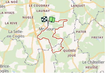

Length
12.4 km

Max alt
168 m

Uphill gradient
159 m
Km-Effort
14.5 km

Min alt
118 m

Downhill gradient
163 m
Boucle
Yes
Creation date :
2019-06-04 07:17:47.881
Updated on :
2021-04-28 10:39:56.821
2h26
Difficulty : Easy

FREE GPS app for hiking
 SityTrail
IGN / Geographical institutes
SityTrail Plus
The world is yours!
About
Trail Nordic walking of 12.4 km to be discovered at Brittany, Ille-et-Vilaine, Les Portes du Coglais. This trail is proposed by coglais.
Positioning
Country:
France
Region :
Brittany
Department/Province :
Ille-et-Vilaine
Municipality :
Les Portes du Coglais
Location:
Unknown
Start:(Dec)
Start:(UTM)
625174 ; 5367039 (30U) N.
Comments